
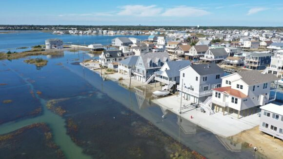
New Jersey law ensures the public’s right to access coastal shorelines and waters. To help people know where to access tidal waterways and get information about the amenities at each location, the state has an online map that shows over 3,900 public access points. However, the impacts of climate change are likely to affect public access to New Jersey’s coast. Many locations are already experiencing flooding several times each year from high tides, sea level rise, and/or storms.
At the end of September, the Jacques Cousteau National Estuarine Research Reserve (JC NERR) partnered with the New Jersey Department of Environmental Protection and Rutgers University to publish the “Flood Exposure Assessment and Potential Adaptation Actions for Coastal Public Access Locations in New Jersey“. The purpose of this project was to assess inundation risk and identifying planning and adaptation options critical to building resilience to flooding impacts. As a first step, the NJDEP directed a team from Rutgers University to assess flood risk at public access points in 15 municipalities across New Jersey’s diverse coastal regions.
Within each municipality, the analysis included all access points featuring any of the following amenities, as reported in the existing NJDEP data: playground, pier, boat launch, marina, food and drink, restrooms. A team of Rutgers University students visited each public access point to confirm the amenities, uses, and handicap accessibility listed in the NJDEP data. The team took photographs and used a GPS device to record the location of each amenity. After the initial location assessment was completed, the team completed a flood exposure assessment using total water levels. These multiple flooding types included sea level rise, high tide flooding, and extreme coastal flooding from storms. Using the data obtained in these first assessments, an inundation data analysis was performed, using maps of each access point overlaid with an inundation data layer. This data set provides coastal managers and scientists with a screening-level view of potential coastal flooding impacts.
After the individual municipality analyses were completed, the 50 public access locations were included in a state flood exposure assessment. These locations were comprised of a total of 93 public access points with approximately 275 amenities. From this state assessment, it was determined that New Jersey’s coastal public access points are inherently vulnerable to flooding due to their water-dependent locations and uses. The full report provides a menu of general adaptation strategies developed by the National Park Service to address the physical vulnerability of assets in coastal parks, which may also be applied to public access points and amenities. In addition, the full report notes potential next steps including policy and planning options, additional analyses, and public outreach to build upon this assessment and increase the resilience of coastal public access in New Jersey.
To learn more and view the full report, visit the StoryMap that was created to provide a comprehensive view of this project. The work was developed through a partnership between the New Jersey Department of Environmental Protection Coastal Management Program and the New Jersey Climate Change Resource Center at Rutgers, the State University, with financial assistance from the National Oceanic and Atmospheric Administration. Lisa Auermuller, Amanda Archer, Amy Plantarich, Andrea Habeck, as well as Vanessa Tropiano (Rutgers University) all contributed widely to this project.
Original article at Rutgers Newsroom