Offshore Wind Analysis for New Jersey and Delaware
|
Tuckerton Sub-Region Delaware Bay Sub-Region
|
Background Offshore and coastal wind resource assessments can be used to resolve where wind energy systems can be located for cost-effective power production and to optimize wind turbine design criteria for the area being evaluated for wind energy development. The Rutgers Coastal Laboratory for Applied Meteorology (RU-CLAM), which is part of the Rutgers Coastal Ocean Observation Laboratory (RU-COOL), has completed an extensive wind resource analysis of NJ’s and DE’s coastal and offshore waters out to 50 nautical miles.
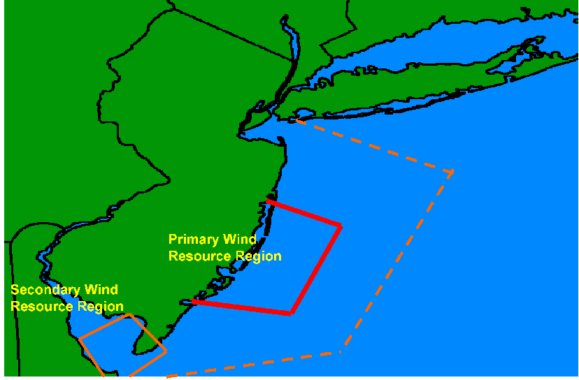
The study domain extends northward to the Raritan Bay, south to Cape May, and includes the coastal and offshore waters associated with the DE Bay (i.e., area within the dashed boundary delineated on the following map). The analysis suggest that the central and south Jersey offshore and coastal waters extending north from Island Beach State Park south to Stone Harbor and seaward to ~25nm encompass the primary wind resource that is most favorable for offshore wind power production. The Optimum Wind Resource, which includes coastal/offshore waters north from Long Beach Island to Little Egg Inlet and south through Atlantic City, is located within +/- 1 standard deviation of the average wind field associated with the Primary Wind Resource. The Secondary Wind Resource selected for wind power production includes the mouth of the DE Bay and adjacent shoreline areas. |
||||||||||||||||||||

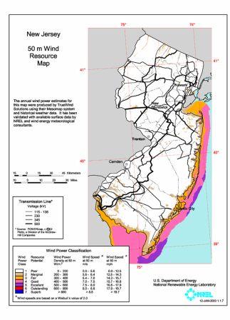
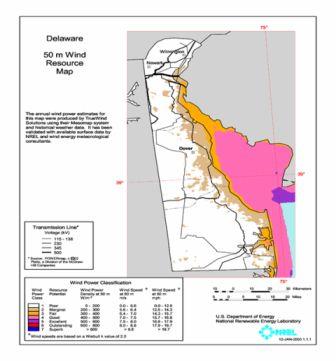
The preceding wind resource maps are adequate for evaluating the general wind resource based on an annual average. A more detailed wind resource evaluation prepared by RU-CLAM can be reviewed by going to the link at the left “NJ/DE Offshore and Coastal Wind Resource Analysis”. The wind resource analysis and resultant model images (wind maps) for the northern, central, and south Jersey coast (including the DE Bay) and adjacent offshore areas are presented as annual, seasonal, and monthly averages at heights of 10m, 50m, 60m, 70m, 80m, 90m, 100m, 150m, and 200m. Higher resolution simulations of the Primary and Secondary wind resource areas can be viewed by going to respectively, the “Tuckerton Sub-Region” and “Delaware Bay Sub-Region” links. The sea breeze will influence the coastal and offshore wind resource. A detailed description of the New Jersey sea breeze can be found as a PDF document using the link at the left titled "New Jersey Sea Breeze and Offshore Wind".
Disclaimer
The technical information contained in this web site should only be used for wind energy development applications that conform to the policies, procedures, guidelines, and regulations documented by the NJ Board of Public Utilities (NJBPU) and the New Jersey Department of Protection (NJDEP). The results and implications of the RU-CLAM analysis address only the wind resource and do not consider environmental, avian, power transmission/interconnections, regulatory, and/or public issues.