| Dataset | blue-20200925T1419 |
|---|---|
| Glider | blue |
| Status | Completed |
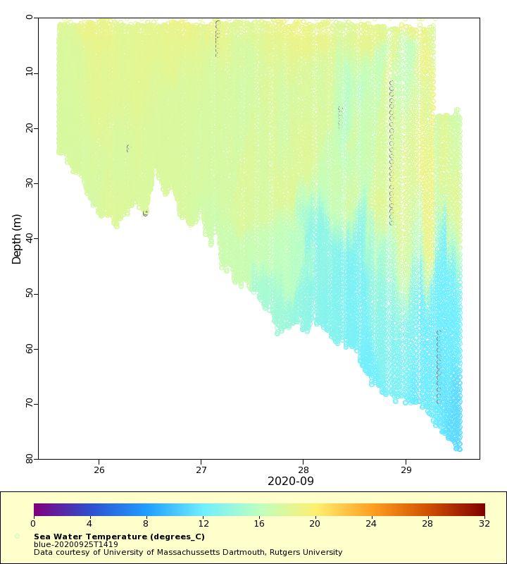
| Summary | This glider deployment is part of continuing Investigation of Mid-Atlantic Cold Pool Dynamics: The Ocean Glider Component. The program goal is to measure the seasonal-varying 1km-100km features of the Mid-Atlantic Cold Pool in order to validate regional and global numerical ocean models and to investigate the Cold Pool's role in modulating hurricane intensity. The glider was deployed south of the Rhode Island Sound. The glider is equipped with a CTD, a WETLabs Scientific 3-channel puck to measure chlorophyll a, backscatter (700nm), and CDOM and an Aanderaa 3830 oxygen optode. The glider will saw-tooth its way southward toward the western corner of the OOI Pioneer Array glider domain and then southwestward for about 100km and then northeastward to its deployment location. This is a re-deployment of blue-20200819T1433 which was recovered due to an internal leak |
| WMO ID | 4801913 |
| Attribution | NOAA |
| Time Coverage Start | 2020-09-25 14:28:07 UTC |
| Time Coverage End | 2020-09-29 12:33:13 UTC |
| Registered | 2020-09-28 |
| Deployed | 2020-09-25 |
| Operator | University of Massachusetts Dartmouth |
| Institution | University of Massachussetts Dartmouth, Rutgers University |
| Data Provider | rutgers |
| # Profiles | 649 |
| Days Deployed | 4 |
| BBox North | 41.362 |
| BBox South | 40.479 |
| BBox East | -71.002 |
| BBox West | -70.911 |
Maps
Track

Latest Profiles
Temperature

Salinity

Density

Conductivity

Latest Timeseries
Temperature

Salinity

Density

Conductivity

Synoptic Timeseries
Temperature
Salinity

Density

Conductivity
