SeaSonde HF-Radar Comparisons with Moored,
Towed, and REMUS ADCP
Josh T. Kohut
The following was presented at:
* 1999 ASLO Conference in Sante Fe, NM
* 1999 HF-Radar Workshop in San Diego, CA
A SeaSonde HF-Radar system was set up in the vicinity of the Longterm Ecosystem Observatory (LEO-15) this past summer. The Coastal Ocean Dynamics Applications Radar (CODAR) was used to measure surface current fields as part of a National Ocean Partnerships Program (NOPP) funded project to study coastal upwellling. For a complete list of sponsors Click Here. The system consists of two remote sites and a central site. (Figure 1.) To learn more about the physics and methodology behind this current measuring system Click Here.
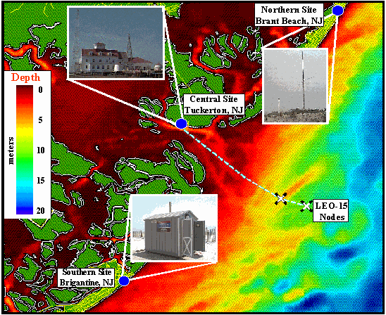
Figure 1. CODAR Site Locations and Illustrations.
To test the validity of CODAR derived surface current fields, measurements were compared to other instruments collecting data during the same time. The radial vectors obtained from each site were tested against moored, towed, and REMUS Acoustic Doppler Current Profilers (ADCP's).
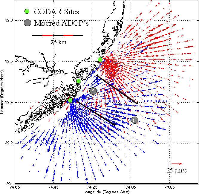
Figure 2. Radial Coverage Areas as well as Comparison ADCP Locations.
There were two moored ADCP's located at station A and C. The underwater autonomous vehicle REMUS ran transects between these two stations. The two black lines depict the towed ADCP transects that were also used in the following comparisons. All of the ADCP derived current vectors were rotated into radial and cross radial directions so that they could be directly compared to raw CODAR radial velocities.
Time series comparisons at station A reveal a discrepancy between the two CODAR sites. Notice that the northern site has more data dropouts and a higher RMS difference.
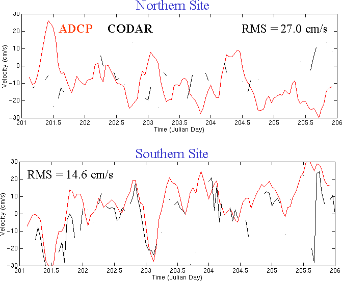
Figure 3. Raw Radial Vector Comparison Between CODAR and Staion A ADCP.
Comparisons done at Station C (further offshore) show much better agrrement between the two CODAR sites as well as much lower RMS differences.
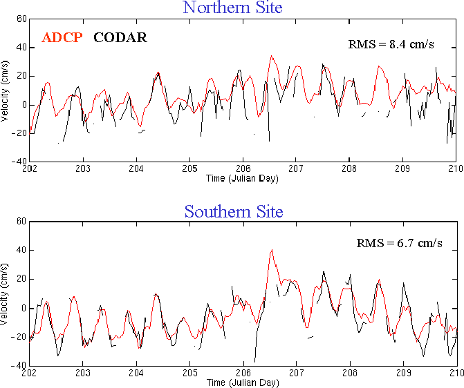
Figure 4. Raw Radial Vector Comparison Between CODAR and Staion C ADCP.
The RMS difference is the summation of several error sources. There are errors associated with each system as well as those due to different measurement methods. The ADCP is a point measurement at a depth of 3.5 meters below the ocean surface. The CODAR system, on the other hand, is measuring the average velocity of top meter over an area of several square km. To minimize some of the errors associated with these spatial differences, tidal velocities were calculated based on a least squares fit to the two time series. Since the tides do not vary as much as the raw currents on the given spacial scales, it is a good measure of the any bias that may exist between the two systems. This is evident in the graphs shown in Figure 5.
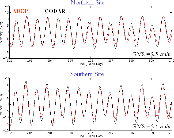
Figure 5. Tidal Radial Vector Comparison Between CODAR and Staion C ADCP.
The difference in RMS values as one moves from station A to C prompted a more thorough examination of the spatial variability in the RMS difference fields. To do this a time series of ADCP towed data was consrtucted at CODAR data points that fell along the two transect lines. An RMS difference value could then be calculated at each point along these teransects, as was done for station A and C. Using all of the CODAR points that were within 1 km of the ADCP transect line, the resulting RMS values were plotted versus distance and angle from a particular CODAR site.
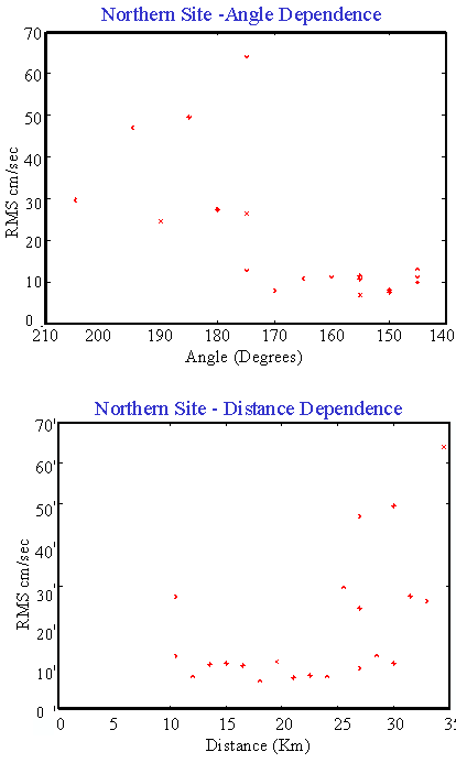
Figure 6. Distance and Angular RMS Difference Dependence for the Northern CODAR Site.
The above figure illustrates a dependence on both distance and angle as measured from true north for the northern CODAR site. These RMS values have an additoinal error associated in them as a result of the averageing times. All of the towed ADCP data was averaged over two minutes while the CODAR data was averaged over one hour. Therefore any currents that oscillate at with a period on the order of minutes to tens of minutes will be resolved by the towed ADCP and not CODAR.
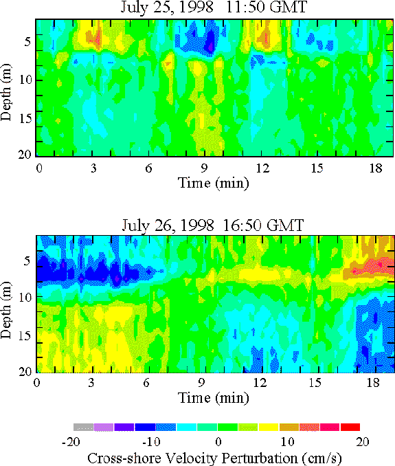
Figure 7. Cross-shore Velocity Perturbation (Mean Removed) as Measured by Station C ADCP.
(Data Courtesy of Dr. Robert Chant - Rutgers University)
The above figure depicts cross-shore currents measured by the station C ADCP after the mean velocity is removed. The relatively large oscillations, on the order of 30 cm/s, could account for some of the RMS shown in Figure 6. To further illustrate the influence of these high frequency internal waves on the comparisons, a REMUS transect is shown below.
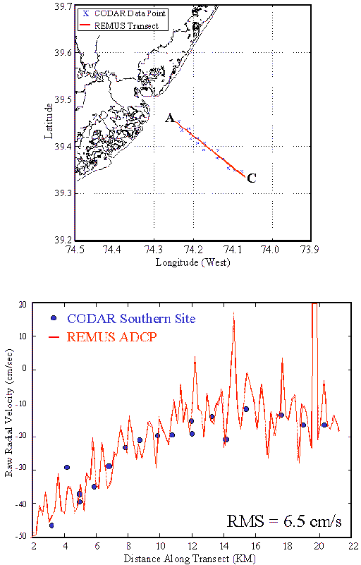
Figure 8. CODAR Comparisons Along a REMUS ADCP Transect.
The figure nicely illustrates the high frequency variability (perturbation) of the REMUS data and the hourly averaged (mean) CODAR data.
The CODAR System set up this past summer proved to be a valuable tool for measuring surface currents in the vicinity of the Longterm Ecosystem Observatory. The analyisis discused above verifies the CODAR data collected against several ADCP platforms. The presence of the internal wave activity is not constant in time and promptss a closer look. I can better understand the infuluence of these oscillations on the RMS difference by going back through the data and seperating the analysis into times with and without internal wave oscillations.
Questions or Comments?
kohut@arctic.rutgers.edu