The Regional Ocean Modeling System (ROMS), in conjunction with a multiple-nested COAMPS meteorological analysis, has been configured for a region of the southeastern New England shelf. Using the coupled ROMS/COAMPS model, ocean conditions in the environs of the CBLAST-Low observational area are being forecast for the 2003 Intensive Observing Period. The high-resolution (3 km) COAMPS 60-hour forecast is run every 12 hours by Shouping Wang of NRL-Monterey, and is automatically transferred to Rutgers University where the CBLAST ROMS ocean forecast is completed approximately 12 hours into the forecast cycle.
Forecast ocean conditions are presented at http://marine.rutgers.edu/~wilkin/wip/cblast/2003_forecasts
Results displayed include 3-hour interval horizontal maps of temperature and currents at 5-m depth, and 2-day forecast simulated drifter trajectories. The forecast particle tracks are presented to assist in planning deployments of drifting instrument strings during the IOP. Vertical temperature sections and time series plots are planned.
ROMS is a free surface primitive equations ocean model being used by a rapidly growing user community for applications from the basin to coastal and estuarine scales (e.g. Haidvogel et al. 2000, Marchesiello et al. 2003, MacCready and Geyer 2001). Model features are summarized briefly in Table 1 and the computational algorithms are described in detail by Shchepetkin and McWilliams (1998; 2003a, 2003b). Careful formulation of the time-stepping algorithm allows both exact conservation and constancy preservation for tracers, while achieving enhanced stability and accuracy in coastal applications where the free surface displacement is a significant fraction of the total water depth. Conservative parabolic-spline discretization in the vertical has greatly reduced the pressure-gradient truncation error that has plagued previous terrain-following coordinates models.
| Table 1: ROMS model features | |
| - free surface, hydrostatic primitive equations model in
terrain-following coordinates - 3rd-order upstream-biased advection (Shchepetkin and McWilliams, 1998) - pressure gradient and equation of state give reduced s-coordinate truncation error (Shchepetkin and McWilliams, 2003a) - split-explicit time-stepping of barotropic and baroclinic modes constrained for conservation of volume and tracer constancy (Shchepetkin and McWilliams 2003b) - radiation open boundary conditions and 1-way embedding in exterior model domains (Marchesiello et al. 2001) |
- synchronous Lagrangian particle tracking - vertical turbulence closures: KPP (Large et al. 1994) and the Generalized Length Scale scheme of Umlauf, and Burchard, 2003 (http://www.gotm.net) encompassing k-e, k-w and Mellor-Yamada (1982) - intermittent sub-optimal melding assimilation - tangent linear and adjoint codes written; 4DVar assimilation in development (Moore et al. 2003) - atmospheric, oceanic, and benthic (wave and current) boundary layers (Styles and Glenn) - coupled ecosystem (7-component NPZD and EcoSim bio-optics) and sediment transport (USGS Community Model) modules |
To provide useful forecasts of the regional heat budget south of Martha’s Vineyard, ROMS should capture the essential features of the 3-dimensional heat transport on diurnal to several day time-scales, and spatial scales of order 1 km. To achieve this, we have employed a high degree of realism in the configuration of model bathymetry and forcing. The present model has fine grid spacing (1 km) and realistic bathymetry from the NGDC Coastal Relief Model, active/passive inflow/outflow open boundaries (Marchesiello et al. 2001) incorporating a bi-monthly climatology of shelf circulation provided by C. Naimie of Dartmouth University, and tidal forcing from an ADCIRC model of the western Atlantic (Luettich et al. 1992). Air-sea heat and momentum fluxes are calculated by the bulk formulae of Fairall et al. (1996) using the model sea surface temperature and COAMPS sea level air temperature, pressure, relative humidity, 10-meter winds, and downward long-wave and short-wave radiation.
The 160 x 380 resolution grid with 20 vertical levels requires approximately 2 CPU mins per model day on 16-processor HP/Compaq Alphaserver.
The CBLAST observations include precise measurements of air-sea fluxes of heat, momentum and mass, and vertical profiles of turbulent mixing throughout both the atmospheric and oceanic boundary layers. Accordingly, these observations are ideally suited to evaluating key components of a coupled ocean-atmosphere modeling system.
Future analysis of the coupled model simulations will focus on critically comparing observed and modeled vertical turbulent mixing processes and the exchanges of momentum and heat across the air-sea interface. A systematic evaluation will be undertaken of the performance of a suite of vertical turbulence closure parameterizations used widely in ocean models. The coupled model will also be employed to complement analysis of the CBLAST observational data themselves. The model will provide a quantitative assessment of the relative contributions of horizontal stirring and advection to the detailed, yet principally 1-dimensional, vertical heat budget analyses of air-sea flux and vertical mixing observations from the Martha’s Vineyard Coastal Observatory (MVCO). Bringing a 3-dimensional perspective to the analysis is essential given that lateral heat transport processes are largely unobserved by CBLAST array design, yet it has already been shown in work-to-date that these processes significantly affect the local heat budget at the MVCO tower site and adjacent moorings.
The ROMS CBLAST model has been run to hindcast ocean conditions during summer 2002. For these simulations, the atmospheric forcing used was high-resolution (3 km) COAMPS augmented with low resolution (27 km) COAMPS due to some gaps in the high-res forecast archiving, and downward short-wave radiation from the MVCO shore station. These simulations have been used to determine features of the regional ocean circulation and heat budget.
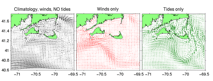
The competing influences of winds and tides in the study region are illustrated in Figure 1, which shows the July mean depth-averaged circulation for idealized cases of winds only and tides only forcing. South of Martha's Vineyard, winds drive upwelling favorable eastward circulation. This is opposed by a westward mean current that branches from a strong tidal rectified anti-cyclonic flow encircling the Nantucket Shoals. Tidal mixing on the flank of the Nantucket Shoals vertically mixes the water column maintaining perpetually cold sea surface temperatures (Figure 2).
|
| Figure 1: Depth-averaged mean currents for idealized simulations with winds only and tides only forcing. |
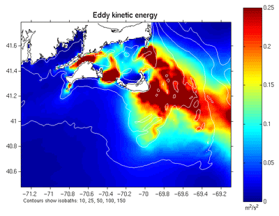 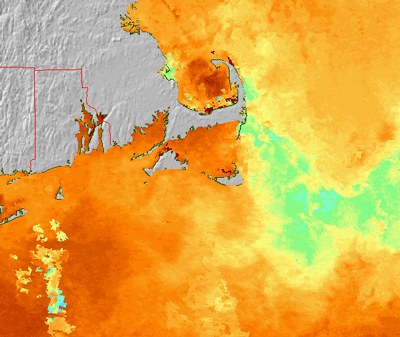 |
| Figure 2: Left, July 2002 mean eddy kinetic energy. Right, 3-day composite SST for 30 Aug, 2002. Tidal mixing generates a region of perpetually cold SST on the eastern flank of the Nantucket Shoals |
The mean depth-averaged heat budget (Figure 3) shows net air-sea flux (Qnet) is greatest east of Nantucket Sound in the region of consistently cool SST, and is largely balanced by horizontal divergence due to tidal mixing. Ocean temperature increase (storage) during July is largest south of The Islands, where surface heating is still warming the water column whereas in shallower water the temperature has reached its summertime equilibrium.
 |
| Figure 3: Modeled mean July 2002 depth-integrated heat budget terms. |
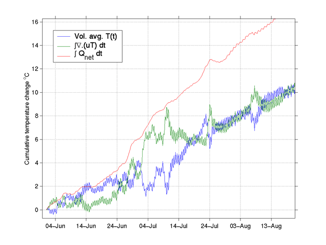
Horizontal divergence is low south of Martha's Vineyard, indicating an approximate 1-D vertical heat balance. Five air-sea interaction meteorological moorings (IMET) were deployed in this region during 2002. For the 2003 observational period, the same IMET sites have been augmented by additional subsurface temperature moorings. These data are ideally suited to evaluating the ROMS simulated net heat budget and the influence upon this due to vertical turbulence closures. Analysis is proceeding to diagnose time series of individual terms in the heat budget for selected regions. For example, Figure 4 shows the equivalent heating in oC for a box enclosing MVCO. In contrast to the area further south, lateral heat transport is significant here, with only half the air-sea flux going to warming the water column while half is removed by lateral divergence. Of this, time mean advection cools the MVCO box at, on average, 200 W/m2, while the temporal eddy divergence warms the region at 50 W/m2. Figure 4b also shows that strong episodic positive divergence (cooling) events briefly arrest the warming trend. Further analysis will determine whether these events are associated with wind-driven upwelling or lateral advection of cool water anomalies. Analysis to date therefore demonstrates that remote mixing and advection significantly influence the heat budget in the environs of the MVCO site, and these processes will need to be quantified in order to interpret the air-sea flux and vertical mixing observations at the ASIT tower.
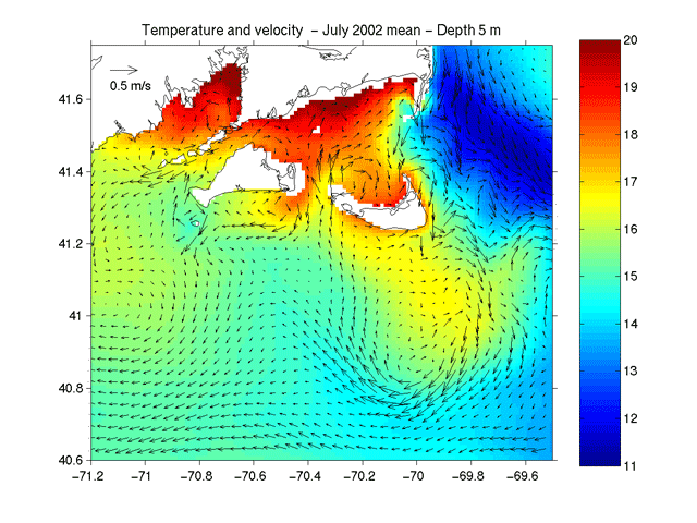
|
| Figure 4: (a) July 2002 mean temperature and currents at 5 m depth. A tongue of warm water issueing from Vineyard Sound through Muskeget Channel encroaches on MVCO but does not warm the region due to opposing mean flow. (b) Time series of terms in the heat budget for a box enclosing MCVO. |
Canuto, V.M., Howard, A., Cheng, Y., and Dubovikov, M.S., 2001. Ocean turbulence I: one-point closure model. Momentum and heat vertical diffusivities, J. Phys. Oceanogr., 31, 1413-1426.
Fairall, C., E. Bradley, D. Rogers, J. Edson, and G. Young, 1996: J. Geophys. Res., 3747-3764.
Galperin, B., L.H. Kantha, S. Hassid, and A.Rosati., 1988. A quasi-equilibrium turbulent energy model for geophysical flows, J. Atmospheric Science, 45, 55-62.
Haidvogel, D.B., H.G. Arango, K. Hedstrom, A. Beckmann, P. Malanotte-Rizzoli, and A.F. Shchepetkin, 2000: Model Evaluation Experiments in the North Atlantic Basin: Simulations in Nonlinear Terrain-Following Coordinates, Dynamics of Atmospheres and Oceans, 32, 239-281.
Kantha, L.H., and Clayson, C.A., 1994. An improved mixed layer model for geophysical applications, J. Geophys. Res., 99, 25235-25266.
Large, W.G., J.C. McWilliams, and S.C. Doney, 1994: Oceanic vertical mixing: A review and a model with a nonlocal k-profile boundary layer parameterization, Rev. Geophys., 32, 363-403.
Luettich, R. A., Westerink, J. J., and Scheffner, N. W., 1992: ADCIRC: An advanced three-dimensional circulation model for shelves, coasts, and estuaries, Tech. Report DRP-92-6, U.S. Army Engineer Waterways Experiment Station, Vicksburg, MS.
MacCready, P. and W.R. Geyer, 2001: Estuarine salt flux through an isohaline surface, Journal of Geophysical Research, 106, 11629-11637.
Marchesiello, P., J.C. McWilliams, and A. Shchepetkin, 2001: Open boundary conditions for long-term integration of regional ocean models. Ocean Modelling, 3, 1-20.
Marchesiello, P., J. C. McWilliams, and A. Shchepetkin, 2003: Equilibrium Structure and Dynamics of the California Current System, J. Phys. Ocean.
Moore, A.M., H.G. Arango, A.J. Miller, B.D. Cornuelle, E. Di Lorenzo and D.J. Neilson, 2003: A Comprehensive Ocean Prediction and Analysis System Based on the Tangent Linear and Adjoint Components of a Regional Ocean Model, Ocean Modelling, in press.
Shchepetkin, A.F. and J.C. McWilliams, 1998: Quasi-monotone advection schemes based on explicit locally adaptive dissipation, Mon. Wea. Rev., 126, 1541-1580.
Shchepetkin, A.F. and J.C. McWilliams, 2003a: A Method for Computing Horizontal Pressure-Gradient Force in an Oceanic Model with a Non-Aligned Vertical Coordinate, Journal of Geophysical Research, 108, 3090-.
Shchepetkin, A.F. and J.C. McWilliams, 2003b: The Regional Ocean Modeling System: A split-explicit, free-surface, topography-following coordinates ocean model, unpublished manuscript.
Umlauf, L. and H. Burchard, 2003: A generic length-scale equation for geophysical turbulence models, J. Mar. Res, accepted.
Warner, J.C., C.R. Sherwood, H.G. Arango, R. P. Signell and B. Butman, 2003: Performance of four turbulence closure methods implemented with a generic length scale method, submitted to Ocean Modelling.